
I started my morning in a new state….Wyoming, and it was cold!

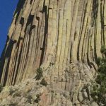
My first stop today was a place that, although it has been in existence for hundreds of thousands of years, it was made famous in 1977 when Richard Dreyfuss created a model of it in his living room that started from his mashed potatoes….

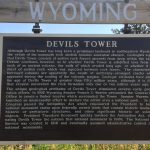
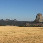
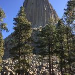
My first stop…..Devils Tower National Monument (Wiki). As with some other places on this trip this is a place I have known about for many years (from the movie) and just wanted to see for myself and I have to say as far as geological structures go it was pretty impressive. It’s one of things that, even though it can be explained by modern science (or so they say), you stand and look at it and just wonder “how did this happen”. Unlike the Badlands (see previous post) or other locations where the whole area is the same this is just out there completely by itself with nothing like it anywhere in site. If I was an alien and I was planning a trip to Wyoming this would probably be my choice as well. 🙂

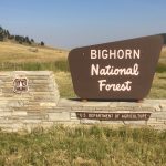
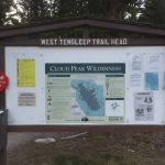
After walking the path around the tower, I said goodbye to ET 🙂 and drove to Buffalo, WY (Wiki, Images). What is the significance of Buffalo WY you ask…well, nothing that I know of. It was just on the way to my next destination. 🙂 Although I will say it is a nice little town. I filled the tank (both on the car and mine) and bought a few groceries to prepare for the next few days. Before leaving Buffalo I stopped at the National Forest Service office to try (unsuccessfully) and get some information on my next destination….Bighorn National Forest (Wiki, Images). All I ended up with was an overpriced (map that didn’t really help) and no more information than when I walked in. Disappointing for sure.
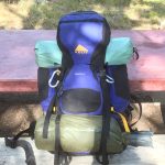
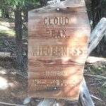
I arrived in Bighorn about 2 hours before sundown. After doing a small amount of research (basically…what’s the highest point in the park & looking at AllTrails) I had decided to spend a couple of days doing Cloud Peak (Summit Post, AllTrails, Wiki). The drive on rt. 16 into Bighorn was very pretty. It took about 45 minutes to reach the gravel road that took me 7 more miles to West Tensleep lake and campground. I had hoped to arrive early enough to hike the 8 miles to camp at Misty Moon Lake but I knew that was not going to be possible today. Once I turned onto the gravel road I knew immediately this was going to be good when I saw a moose and her calf on the drive to the camp. I grabbed a campsite at West Tensleep, made dinner, prepared for tomorrow and feel asleep listening to moose bellowing all around….it was soooo cool!!!
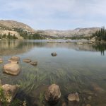
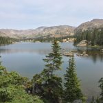
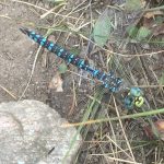
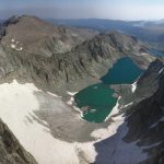
The next day I started later than I wanted. I mean, I wasn’t on a “schedule” so I figured I would just take my time. This is something that I’m actively trying to learn…..to be more “laid back” and “flexible” and to just take my time and live in the moment when I have the opportunity. So on my way to my intended camping area I stopped and chatted with a few folks and took a lot of pictures (I always do that). I saw the most interesting looking dragon fly on the trail. If you look closely at the picture below it looks like he is smiling…I like to think he was happy to see me and have his picture taken. 🙂 Further up I came to the first of three beautiful lakes, Lake Helen, Lake Marion and Mistymoon Lake. Like most high alpine lakes I’ve ever seen they were all beautiful. It was at the first lake (Helen) that I got the first glimpse of my “objective”, Cloud Peak.
Click here to see a 360 view on the trail above lake Marion
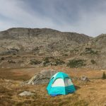
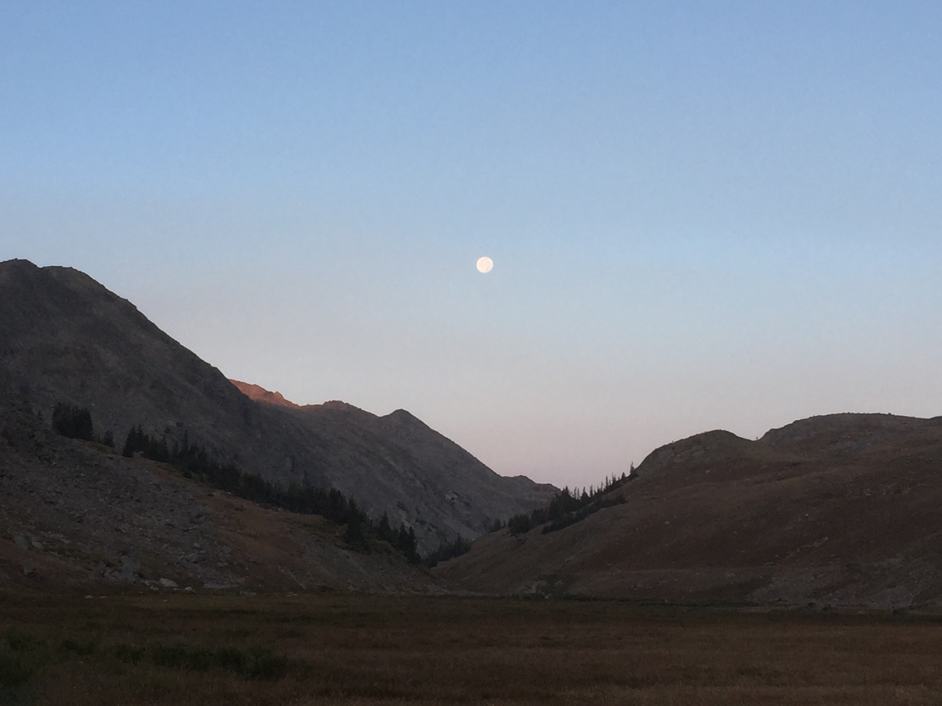
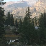
I had originally planned to camp beside Mistymoon Lake. When I arrived there were 3 tents so I sat for a few minutes to rest before setting up. While I was sitting there 4 ladies on horseback road by. They were very familiar with the area (one had actually hiked Cloud Peak) and they all said that I should continue over the pass and down into the Cloud Peak valley and camp there as it would be a better spot to begin my accent the next day. At this point it was only a little after 3 so I thanked them and continued on over the pass. From the top of the pass I could really get a good look at Cloud Peak. I topped the pass and started down the other side toward the valley. About halfway down I thought, “the further I walked down into this valley the further I have to carry my full pack back up tomorrow”, so I found a good flat spot about halfway down and setup camp. Unlike the lake that already had 3 tents there was no one as far as I see at this point….I had the whole valley to myself and I liked that (see pic below). I setup my tent, made dinner and watched the sunset and a beautiful full moon rise over the valley….just fanatic!
Click here to see a 360 of my campsite on the rim of the Cloud Peak Valley
Click here to see a 360 view from the Cloud Peak Valley
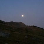
After a good nights sleep I was awakened by the sound of someone coming down the trail. I opened my tent to look out. It was still mostly dark but daybreak was coming soon. As I was preparing my breakfast….I ALWAYS eat breakfast 🙂 the moon was still in the sky as the sun was rising. Just as I ended my day yesterday this day began with an amazing sky! I just LOVE this!!!
During my hike in yesterday I passed about 12 people who had “attempted” the Cloud Peak summit. Of the 12 only 1 had actually made it to the summit! And they all had hiked between 8 – 13 hours! Needless to say that was a little concerning. So I ate quickly and hit the trail a little after 7 as I wanted to give myself plenty of time. Down in the valley, just before you begin the climb, there is a beautiful creek and waterfall. I carry 2 water filters when I hike so not knowing if there was water further up I stopped here and filled my water bottles.
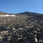
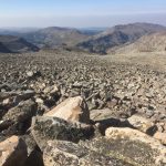
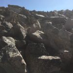
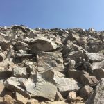
The first mile or so of the climb was steady but not bad. Although there is no “official” trail to the summit there is a pretty well defined path (at this point) and it the pace was pretty good. As I continued to climb the rocks became more frequent and larger….much larger. About 1.5 miles up I hiked over a pretty good hill and down into a wet land area and then there it was….I “face” of boulders basically going straight up as far as I could see. What I didn’t know at this point, or I may have turned around :-), was that this is how it was all the way to the top (probably 2 miles). I had read that there was not really a “trail” once you hit the rocks and that was certainly true. There were some small rock cairns (Wiki) every now and then but that was it. A couple of the people I met the day before had told me to “stay to the right of the big snow bank” so that’s basically what I did as I scrambled over huge boulders for what seems like hours….I guess because it was! 🙁

Click here to see a 360 view from the narrows on the hike up Cloud Peak
As I continued to hike up I passed several fields of snow remaining from last season. I know most, if not all, of these are consider glaciers as they are persistent year around. However, most glaciers around the world are receding at an alarming rate (I learned this while I was in New Zealand last year, Wiki) and I’m sure these are no exception. I’ve read that at the current rate there will be no glaciers remaining in Glacier National Park within 25-50 years (Melting Glaciers at Glacier NP).
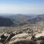
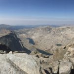
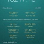
At just about 4 hours and around 4000′ of climbing (5700′ from West Tensleep campsite) I finally made the summit! I had set a goal of 3:30 so while I didn’t make that I was happy with 4 after all the unsuccessful climbers I met yesterday. I will confess there were at least a few times during the climb that I was highly tempted to turn around. But once I made the top and looked down into the valley on the far side it was all worth it….well, that’s what I told myself anyway. 🙂 The view on the other side was amazing!
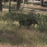
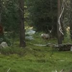
I stayed at the top for probably 45 minutes enjoying the view and posting to FB as this was the first place I had cell service for 2 days. After that I started the journey back down. While it was not as strenuous most anyone will tell you that going down is often more technically challenging and harder on the knees, ankles and thighs. It took almost 2 hours to get back to the waterfall in the valley. When I reached it I filled my water bottles again, hiked up to my campsite, made/ate some lunch, broke down/packed up and headed out. During the hike out I passed a few people (one guy from the day before) and had some brief conversations but I was trying to get back to West Tensleep before dark and I had 8 miles to go so I kept moving at a pretty good pace. With that said, I did take a few minutes just below the lakes to stop and admire this guy….
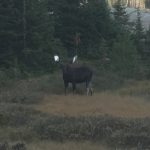
He was standing beside a small pond and looking right at me when I came around the corner….so he knew I was there. At first I was a little startled because he was huge and only about 25 yards from me. Once I realized he wasn’t concerned about me I took several pictures and just stood and watched him. I loved the white in his horns. I’ve seen moose before but have never seen one with the white like this. Unfortunately the pictures are not great because I only have my phone (no “good” camera) and it was getting darker but I’ll always remember the moment. In the one picture you can see him standing beside the pond with Cloud Peak in the background. After about 10 minutes I moved on and left him to his beautiful land.
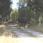
About 2 miles further I came across this guy….
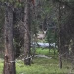
Again, no good camera and even darker so the pictures are not great but he was awesome as well. As if I needed one last reason to fall in love with Bighorn National Forest.
I continued my hike out and made it back to my camp area at West Tensleep lake about 20 minutes before dark. I started the day with the 4000′ climb of Cloud Peak and logged 16 miles total. Needless to say I was pretty beat at this point. I quickly made/ate supper, setup camp and fell asleep….to the sounds of moose in the distance. What a good day!
I would highly recommend Bighorn National Forest and I hope to come back some day.
To view many more pictures related to this blog click here: US & BC Canada 2017 Pics – Wyoming
To view ALL videos related to this blog click here: US & BC Canada 2017 Videos