
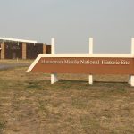
I woke fairly early this morning, ate breakfast and hit the road anxious to visit my first national park on this trip. But as I was driving down I-90 I saw a sign for the Minuteman Missile National Historic Site (Minuteman Historic Site, Wiki) at the next exit. It sounded pretty interesting and since I wasn’t on any particular schedule I figured why not.
Although I have always known that most of the US missile silos were located in the western plain states it didn’t even cross my mind that I was driving right through the middle of “ground zero” (as they referred to it at the museum). While I can recall the “cold war” and the Intermediate-Range Nuclear Forces Treaty (Wiki) between Russia and the US in the 1980’s I really didn’t know very much about it and/or what ever happened with it. Apparently (according to the information at this museum) the US and Russia agreed that each side could keep one of the sites (after disarming) as a museum, and this was the one for the US.

It was a very interesting, concerning and to be quite honest, scary exhibit to walk through. It went through the history of the development and creation of the first nuclear weapon (US on Japan) and then told the story of the next 40 years of escalating tensions between the US and Russia and the insanity (my word) of both sides practicing what was called MAD or Mutually Assured Destruction (Wiki). The theory being that both sides knew a first-strike launch would result in their total destruction as well. Of course, this did not account for other nations developing their own nuclear weapons (Countries with nuclear weapons) or the possibility of a launch due to an accident or human error. Speaking of which, there was a whole section of declassified “incidents” over a 30 year period where we were 1 or 2 steps away from a launch. They listed two men, one from the US and one from Russia (different incidents) that were both credited with “saving the world” because they did not “push the button” during a technical issue where the systems were telling them to launch. Holy Cow! And I can only assume there were more that the average person will never know about.
It also told the story of the people who actually manned the underground launch facilitates 24x7x365 for over 40 years. It showed the process and timeline from a Soviet launch (it of course assumed the US would never launch first) through the US detection, confirmation, approval & command to counter launch and the process the men (and later women) in the underground launch facility had to follow. From the time of launch to target impact in Russia was only 25 minutes!
A couple of other interesting things I recall was the size of the warheads and the location of the silos. Since the bombs dropped on Japan are the only nuclear weapons ever used (thankfully) everything since has been compared to that. The US Minuteman Missiles carried 1.5 megaton warheads. However, the similar Russian missiles carried 10 megaton warheads! As for the location, I always assumed they chose the open plain states because of the vast amount of open land, and that is partially true. But the main reason was because of the proximity to Russia. The fastest air route to Russia from the US is from the plain states directly over the North Pole. So that was the #1 reason they chose the plain states…they provided the fastest route to Russia.
So as I said, it was a very interesting, concerning and scary exhibit but I’m definitely glad I took the time to stop. They also had a guided tour of the underground control center (about 5 miles away) but it was scheduled for the middle of the day so I knew I could not make it. And there is a self guided tour of the missile silo (Missile Silo) about 10 miles away that I meant to do after I visited Badlands but totally forgot…ugh! But you can listen to the self guided tour by dialing (605-301-3006) if you want. I did it and it was pretty interesting. So on to something else….
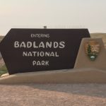
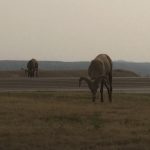
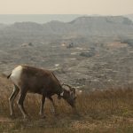
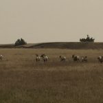
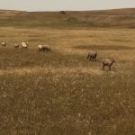
My next stop was the first of many National Parks on this trip. I was super excited as I pulled up to the entry gate at Badlands National Park (Badlands National Park, Wiki, Images). The park entrance for a day was $20 but I had already decided I was going to purchase the $80 all annual pass for all US National Parks since I knew I was going to visit several more on this trip. I got my pass and drove about 20′ and these guys were just standing around grazing and paying no attention to anyone. I suspect they are actually employed by the National Park Service to get the visitors excited. I mean, seriously, 10 seconds inside the park? ha ha
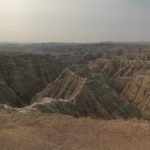
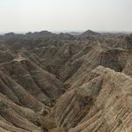
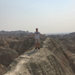
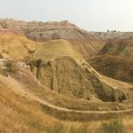
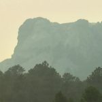
I said goodbye to the sheep and drove about 2 miles to the first viewing pull off. I will let the pictures do the talking (although I know they will not come close to justice for how it looks in real life) as I really have no words to describe it other than “unbelievable” and what my good friend Dave Armbruster said about Western South Dakota, “It’s other worldly”….
To view a 360 of Badlands click here
To view a second 360 of Badlands click here
I made quite a few stops in Badlands, did a few short hikes into the canyons and visited the visitors center, went through the exhibit (not nearly as disturbing as the one early this morning) and watched the video regarding the history of the park and it’s early inhabitants. It also provided more information regarding the Lakota people as the Wounded Knee Massacre occurred just South of Badlands park (see previous post for more information on the Lakota).
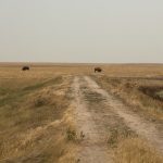
Just before leaving the park I took a short trip down a gravel road that went to a more remote part of the park. As soon as I turned down the road I saw a pack of Bighorn Sheep and further down I saw the first Buffalo of the trip.
Needless to say my trip to Badlands did not disappoint. It was a great “teaser” for many more parks to come.
I left Badlands before noon and drove to Rapid City SD (Wiki). In Rapid City I stopped at a Walmart to stock up on some food and replenish my ice and then I was off to the Black Hills!
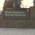
I thought the Black Hills (Black Hills NF, Wiki) was a National Park, meaning a gate, cost, etc. However, I discovered that it’s actually a National Forest with no defined gates or admission charges…ok, fine with me except I now have my all access annual pass and I’m dying to use it and get my money’s worth. (ha ha….it’s already payed for itself) It took about 45 minutes to get to my next planned destination….Mount Rushmore (Mount Rushmore, Wiki).

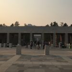
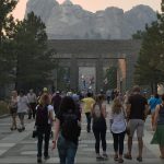
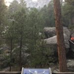
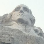
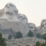
At the foot of the mountain is a town called Keystone (Wiki). As I was driving up the mountain out of Keystone I got my first glimpse of Mount Rushmore and I have to admit, I was surprised with my reaction when I first saw it. It kind of choked me up and gave me a feeling of patriotism. I turned into the parking area and paid my $10 to park (I had read that entrance is free since it is a National Monument (no charge for monuments) but you have to pay to park…and it’s not covered by the annual pass! (ha ha) So I parked and began to walk toward the mountain and when I saw it, I again was a little choked up. It’s kind of hard for me to describe but you walk up this large marble walkway. The first thing you come to is a gift shop on the right and bathrooms on the left. Then it is open with woods on both sides (still on the marble walkway) and then you come to another set of buildings with a restaurant on the right and I’m not sure on the left (I didn’t go there). At this point you have a great view of the mountain.
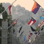
You continue to walk toward the mountain through the “avenue of flags” with all the states, their flags and their inception dates. Once you get through this you are standing in a large open area looking straight up at the mountain and it is AMAZING!!! After seeing it in pictures, videos, movies, etc. my whole life it was hard to believe that I was actually standing in front of it. It was a definite WOW moment and I just stood there and took it all in.

To view a 360 of Mount Rushmore click here
I had read that they had a nightly lighting ceremony at 8 PM. It was already 6 and I still wanted to take the walk and go through the museum so sticking around for the lighting ceremony was a no brainier. The walk tells about each of the presidents and why they were chosen for the monument and the museum tells about the , why this mountain was selected and the story of the how it was built. I really enjoyed it.

The lighting ceremony was nice but nothing spectacular. One thing I did like is that they had all current and previous US service men & women come down and participate in the raising of the American flag toward the end of the ceremony. That was pretty cool. And the monument definitely looked really cool with the lights shining on it. As usual I took way to many pictures (you can see more at FLICKR by clicking the link at the bottom and searching for “rushmore”).


One last note on Mount Rushmore…after I left the parking area I drove down the road and all of the sudden I looked up and you could see a profile of the Washington Memorial. The sky was completely dark except for the bright lights shining on Washington. It looked pretty cool…and a little weird as it appeared to just be “floating” in space. 🙂

And that was it for Day 9. It was a very busy day but a really good one. I hope you enjoyed it as well.
Remember:
To view ALL pictures related to this blog click here: South Dakota – US & BC Trip 2017
To view ALL videos related to this blog click here: South Dakota – US & BC Trip 2017